Advancing Sustainable Agriculture in Uganda: 3DroneMapping's Aerial Survey for Irrigation Development in Iganga
- Charlie Wijnberg

- Feb 6
- 3 min read
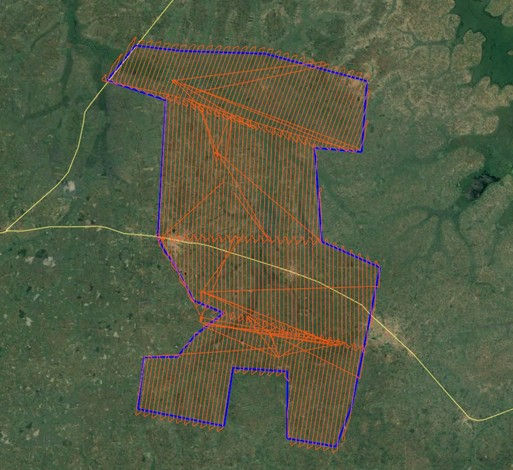
At 3DroneMapping, we deliver precise geospatial solutions to support critical infrastructure and agricultural projects across challenging environments. In April 2021, we were engaged by Engineers as consultants to perform a large-scale aerial survey of a proposed irrigation and damming scheme in the Iganga district of Uganda. Covering approximately 31,000 hectares, this project provided essential orthomosaic imagery and Digital Terrain Models (DTMs) to inform planning, design, and implementation of water management infrastructure aimed at enhancing agricultural productivity in the region.

Project Context: Enabling Reliable Irrigation in a Key Agricultural Area
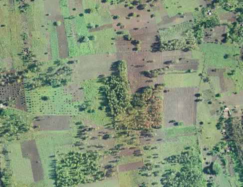
Eastern Uganda, including Iganga district, faces variability in rainfall patterns that can limit crop yields, particularly for water-intensive crops such as rice. Government initiatives and private sector efforts have prioritized the development of irrigation schemes to regulate water supply, support year-round farming, and improve food security and livelihoods.

The proposed scheme in Iganga involved assessing terrain for potential damming, reservoir creation, and irrigation distribution. Accurate topographic data was vital to evaluate water flow, identify suitable dam sites, design canal networks, and ensure environmental and engineering feasibility. Our survey delivered the high-resolution geospatial foundation required for these critical decisions.


Advanced Methodology: High-Precision Data Acquisition and Processing
The survey utilized cutting-edge equipment, including a 50-megapixel calibrated metric camera paired with an Inertial Navigation System (INS) for sub-centimeter positioning and orientation accuracy (1 cm positional and 0.004° angular). A Livox Avia LiDAR scanner, operating at 720,000 pulses per second, enabled penetration through dense vegetation to capture true ground elevations.
Ground Control Network: Ten primary control points were established to 20 mm accuracy using Precise Point Positioning (PPP) with the EGM2008 geoid model for orthometric heights. Markers included durable "T"-shaped painted targets on road medians and iron pegs driven into stable surfaces, selected for optimal sky visibility, minimal disturbance, and longevity.
Quality Assurance: Four additional checkpoints and secondary points (road markings, spot levels) were surveyed to validate data integrity.
Flight Operations: Missions were planned with 70% forward overlap and 35% side overlap to accommodate terrain variations, ensuring consistent coverage and data quality.


Trajectory processing combined PPP and Post-Processed Kinematic (PPK) methods using NovAtel Inertial Explorer, achieving deviations below 1.5 cm in position and 0.003° in attitude despite turbulence from heat and reflective surfaces.
Post-processing followed industry standards with the Terrasolid and Inpho suites, employing direct georeferencing, dense point cloud generation, classification (ground, vegetation, buildings, water), and DTM creation. Bundle block adjustment and radiometric balancing produced seamless orthophoto mosaics.
Independent checks confirmed vertical accuracies better than 5 cm, with point densities of 5-6 points per square meter and 5 cm ground sample distance imagery.
Overcoming Environmental Challenges
The expansive area featured varied terrain and vegetation, including dense cover in some zones. LiDAR technology was key in extracting reliable ground points where photogrammetry alone would be limited. The survey successfully mapped the full extent, providing clear insights into elevation, drainage patterns, and potential water storage sites.
Deliverables and Impact
Delivered electronically , the dataset included:
Orthophoto mosaics in uncompressed ECW format.
Point clouds in LAZ v1.4 format.
Raster DTMs.
Final control point coordinates in CSV format.
All data adhered to WGS84 UTM Zone 36N with EGM2008 orthometric heights.
This high-accuracy geospatial information supports informed engineering design, risk assessment, and sustainable development of irrigation infrastructure, contributing to enhanced agricultural resilience and productivity in Iganga and surrounding areas.

Collaborate with 3DroneMapping on Your Next Initiative
3DroneMapping combines expertise in aerial surveying, LiDAR, and photogrammetry to deliver reliable data for agriculture, water resources, and infrastructure projects. Whether planning large-scale irrigation, environmental assessments, or terrain modeling, our solutions provide the precision required for success.
To discuss how we can support your project, please contact us.


