Drone based LiDAR surveys for the feasibility of renewable energy production
- Melissa Wijnberg
- Sep 28, 2023
- 2 min read

Drone have been used for many years post-construction of renewable energy projects such as solar and wind farms for inspection purposes. The use of a drone based camera setup with either a thermal, multispectral or visible light spectrum sensor is an affordable, safe and fairly quick operation. But drones are becoming increasingly competitive in the pre-construction phases too.

The feasibility studies are critical for renewable projects as they provide a technical summary of a proposed sites' capacity, suitability and profitability. Data from feasibility surveys helps designers and engineers optimise their plant and layout of a potential energy provider. It also is a source of hard evidence for financiers to further justify the expenditure of a large construction project.

In their very nature, feasibility studies do not have very large budgets. They often need to be undertaken rapidly with low costs and with as little impact to the local population as possible. This is to attempt to restrict persons from "speculating" about a potential project and possibly increasing land costs, rental rates or generally trying to profit unduly with prior knowledge.
Our services have been used successfully over the past years to provide such services to potential renewable energy projects all over Africa. LiDAR scans done from our fixed wing UAVs can cover up to 10 000ha per day to produce high resolution DTM and DSM data products that are used by our clients for CFD (computational fluid dynamic) modeling. This is all done in a cost effective manner while keeping our footprint and time on the ground to a minimum.


CFD modeling is used to asses the feasibility of the site for energy recover products such as wind turbines. It allows the user to locate areas over a site given collected wind and other weather data and combine this with accurate terrain roughness or DSM products obtained from drone LiDAR surveys. Operators can also fine tune positions of plant within the simulation to get the best possible energy production.


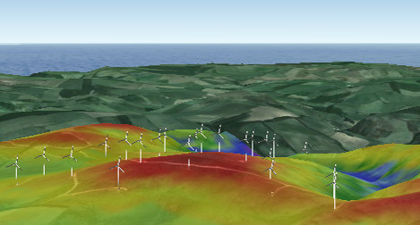
Historically, these DSM products were obtained from Google Earth, SRTM or other sources. While these are free products, they are incredibly rough and inaccurate. These may work for very initial planning phases of a project, but certainly are not suitable for fine level adjustment, planning and calculations for energy production potential of a site. High resolution LiDAR derived DSM combined with CFD modelling gives outstanding results and helps quantify and justify the position of plant for maximum production as well as reliability in terms of yield.


Not only are LiDAR derived DSM products produced, but high resolution orthomosaics are also captured, allowing engineers and designers to carefully plan routes to ferry materials for construction phases, for grid transmission line design and connections as well as spatially locating all other services.
Using a drone based LiDAR system is easily the most affordable and accurate way of undertaking a sites feasibility for renewable energy production.
Contact 3DroneMapping for more information: info@3dronemap.com


